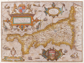
Christopher Saxton was born in Yorkshire in around 1543 and then is thought to have studied surveying at Cambridge possibly under the patronage of Thomas Seckford a wealthy employee of the Lord treasurer. Following early inspiration for a local cartographer in Yorkshire, the Reverend John Rudd, Saxton began a survey of England and Wales sometime after 1570 and the first maps are dated 1574.
After financial problems, his former contacts and patrons in high places managed to secure a ten year licence to practice the trade of map making and selling, granted by Queen Elizabeth herself. Saxton's surveying techniques remain largely a mystery but it has been suggested that his original mentor John Rudd's work could well have been an early basis to which he added and embellished in his own inimitable style.
Saxton's county maps were originally sold separately, their simple quality advertising the forth-coming atlas which was eventually completed and first published as An Atlas of England & Wales in 1574 and again in 1579. He went on to publish in 1583 a 20-sheet wall map of England and Wales, of which only two remaining copies are known.
Today, Saxton maps are one of the most sought after by collectors. The later William Kip and Hole reduced versions, though considerably smaller are often mistakenly identified as actual Saxton maps.
