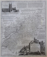
Emanuel Bowen was a print and map-seller by trade as well as engraver to both George II and Louis XV of France. From 1714 onward, he worked in London and was the both architect and creator of some of the most intriguing and appealing maps of that era. One of his long-term plans was to publish a complete atlas of English county maps. It proved to be such an enormous project, Bowen decided to combine the skills (and no doubt pool knowledge and contacts) of fellow mapmaker, Thomas Kichin.
With the atlas in mind, they began to publish individual maps from around 1748 which served as a practical way to advertise their forthcoming collection.Working together like this, they eventually published the appropriately named, The Large English Atlas in around 1760. The maps were indeed the largest county maps of the age, some being around 20" x 27" (510mm x 695mm). The maps themselves featured detailed descriptions in small blocks of text: county towns, historical notes, notable events etc, carefully filling any voids or 'quiet' areas on the maps, and resulting in a stunning montage of topographically and historically fascinating pieces.
A reduced version of The Large English Atlas, The Royal English Atlas, was published later, around 1764. Maps from this work, though very similar in detail to the older version, are significantly rarer now, suggesting that fewer were produced due to lack of interest.
Bowen's name is now frequently associated with a collection of small road maps, or strip maps published around 1720. Bowen worked with partner John Owen on a pocket-sized road atlas entitled: Britannia Depicta. Owen & Bowen developed these delightful strip maps from John Ogilby's master work of 1675, reducing thm in size and embellishing the maps with text giving local details, thus providing one of the first practical travelling atlases. The pages were printed double sided so it was light, required less paper to make and could easily fit in a pocket or saddlebag to accompany the traveller.
Emanuel Bowen's son, Thomas, also produced some beautiful maps. He is known to have helped his father as a youngster, and no doubt acquired some useful skills in the process. As with many other mapmakers of the time, despite their apparent success in the trade, both Emanuel and son Thomas died in poverty and relative obscurity. They did, however leave behind them an remarkable portfolio of both large and small, incredibly detailed and crafted maps and are certainly not obscure today.
